Alternative Names: None
Type of Dive: It's a shallow shore dive (2-5m)
Suggested Experience: Trainee upwards.
Travel directions: From Swansea Get on M4 from the B4489 thru Carmarthen then M4, A48 and A40 to Letterston then follow signs to Trefin.
Parking directions: There is parking for six cars at the top of the path
.
Lat & Long: 51.949502, -5.155605 Postcode SA62 5AY google map
Tides: Tide tables Best dived at HW as access can be tricky at low water (slippery rocks and seaweed)
Depth: .5m max
Site entry/exit: Walk down the stairs onto the path down to the stony beach (155m)


Underwater directions: Head North towards the rock islands and explore that area. There is a tunnel swim through the large island. Rock gullies interspersed with grey sand, large boulders.
Air & Nitrox: WWDC Dive in2 Pembrokeshire
Site Hazards: Some surge and light currents possible. Also swells.
Nearest Public phone: Nearest phone is in Trefin.
Mobile Network service: Contact me
Accommodation:
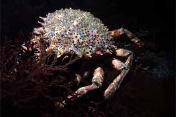
Other comments: Cove faces W. Around to the right (N) there is a rock island with a tunnel through the middle (you can walk through it at low tide). Bottom features include large rocks, gullies, kelp and other seaweeds, flat rock beds and gritty grey sand. Likely fauna includes various species of crab, jellyfish, wrasse, pollack, sand eels, grey mullet, anemones.
Pub: The Ship Inn in Trefin.
Cafe:
Version: 1
Thanks To:
Links:
Created by: Debra Kelbrick
Date: 4/8/20
Surface Photos: Debra Kelbrick
Underwater Photos: Debra Kelbrick


Underwater video: Contact me
Dive sitemap: Debra Kelbrick

Dive Report: Comment in the box below.

